We live at the foot of one of the most gorgeous Mountain Ranges, the Rocky Mountains. Every once in a while, when I was looking up at the mountains, I was wondering how it would be to hike a part of the ridge line. I have been on Mt. Teepee numerous times, so that would be a known start and I knew that there was a trail going up to Saddleback Ridge (see below image). Talking about my idea to hike the ridge line from Mt.Teepee to Premier Lake via Saddleback Ridge to an equally adventurous friend of mine, the plan was formed. We would attempt it as soon as the snow had sufficiently melted. We tried to get as much information about the ridge hike, all we found out was that it had been done but not often and that: "it is much longer and harder than they thought it was going to be and it is a very long day hike. No water along the entire route and lots of serious up and down"
We also hiked up Saddleback Ridge earlier in the year to see where the way down would start. Unfortunately due to the snow we had to abandon our attempt and we didn't make it to the top. But we thought we had a pretty good idea of the surroundings and should find the trail down easily....little did we know...
Last Saturday the day for the big adventure had come!
Prepared with lots of food and water, emergency supplies (just in case we had to stay the night on the mountain), first aid kit..... and in good spirits we started our hike at the Mt. Stevens trail head at 5:30 am.

Route from Mt. Stevens to Premier Lake via Mt. Teepee and Saddleback Ridge

The hike up to Mt.Stevens/Mt. Teepee is described as:
"long, steep, forested trail; extensive elevation gain to moderate exposure on alpine ridge; two high Rockies summits." (1)
and as you can see, that is a pretty accurate description...;-)

Although it was not quite as hot as down in the valley, it was quite warm. Lexie sought out every opportunity to cool down in the bit of remaining snow. She had to wear her own backpack with her food and water, so she really relished these "snow breaks".

Mt. Stevens summit
Soon we had reached the summit of Mt. Stevens and were looking ahead to tackle Mt. Teepee.
Route from Mt. Stevens to Mt. Teepee

The three crazy ladies, Trudy, Lexie and me, enjoying the cold snow

Panorama as seen from Mt.Teepee. Please click on the image for a better view

Hike along the ridge as seen from Mt. Teepee
First, the "back" of Teepee is much steeper than the "front" where hikers usually ascent. Secondly it is covered with huge boulders everywhere. About halfway down we got physically stuck between a rock and a hard place or between the choice to climb a chimney to the right or to the left. We shortly considered going back up and abandon the whole idea, but a quick glance up the mountain told us that that wasn't an option either.
Trudy went ahead and after she successfully made it down I had to figure out how I would get down there. I have climbed through quite a few chimneys before, but never with a 70 lb dog. In order to get a better stand I had to take off my backpack and lower it first. We really had packed a lot of hiking supplies but unfortunately a rope wasn't on the list. So I tried to use the dog leash and actually found a seemingly safe spot for the backpack, wedging the leash under what I thought a secure rock to make sure the pack wouldn't go anywhere. Then I coaxed Lexie into my arms, I wonder what she thought about all that, and hoisted her down. All went well except in the very last minute Lexies' hind legs caught on some rocks, dislodging them and forming a mini rock avalanche that headed right for my backpack. And sure enough, the pack got kicked off and tumbled down the mountain and out of sight...After a brief moment of shock, not only all my water and food had been in the pack but also my camera, we contemplated what to do. I was absolutely not ready to abandon the pack, but would we be able to find it?
How far would that throw us off our path?
Luckily we found the pack relatively quick and the detour wasn't too bad as we would have to circumnavigate the big boulders anyway. But traversing the loose talus on an extremely steep slope is no fun. We sighed an enormous sigh of relief as we finally reached the safety of the ridge.

In the image above you can see our decent to the ridge. The pack tumbled to the lowest point of the green line, close to the snow field. To get an idea of the dimensions, the boulder where I put the pink x was about 2-3 m high.
The descent had cost us almost 3 hrs instead of the 30 min we had thought. But we were safe and happy that we made it. And I was twice as happy that the camera had made it, too, with not even a scratch. For the geeks who are interested: I had my Canon 7D with me, packed in the ACS Photo Pack, a hiking backpack from Jack Wolfskin.

Looking back at Teepee it looks completely innocent and harmless, but I would NOT recommend to anyone descending that way, except maybe if you carry climbing equipment with you. That being said, parts of the ridge were stunningly beautiful and wide, wide open.

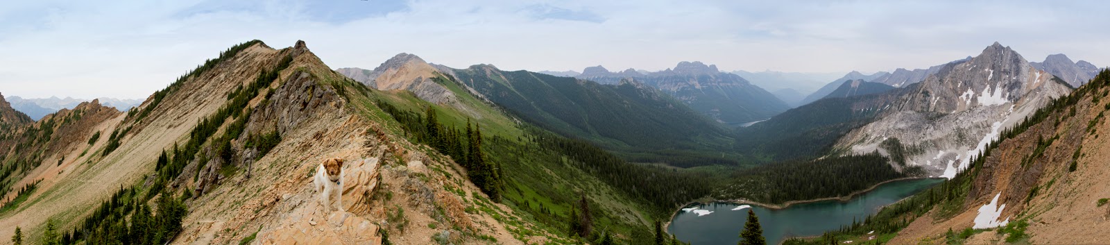
The views just asked for panoramas, so I shot a few and include them here. Please click on the images, especially the panoramas, to show them in a bigger window for better viewing.

Ridge view

While we were looking into a hazy Kootenay Valley to our left, the on the right side the valley was dotted with little turquoise lakes

Wide open, high alpine tundra tracks switched with bouldery, barren stretches that made us scramble and swear.

But the view always kept us at awe.

Another ridge panorama

typical alpine flora to scramble transition
After one of these scrambles we literally stumbled over what looked like a miniature mine shaft.

And it was a mine...Trudy curiously looked inside and retrieved a very old looking coffee tin with another tin inside.

Carefully she had a peek inside and we were looking at handwritten mine stakes from 1967 and 1958.

Unbelievable that these papers survived over sixty years... We were not surprised though that the "mine" wasn't exploited...accessibility is definitevly an issue here...;-)

With the uttermost care we packed the letters back into their respective tins and made sure to leave the place exactly as we had found it.


By the time we saw Premier Lake shimmer below us, it was past 7 pm and we still had to find the trail and hike it down.

Unsure where to go down we finally descended on the most promising looking trail. Soon after that we had to cross what looked like an avalanche field. About half way down the mountain we realized we were not on the right trail. It was starting to get dark and we decided to just go down, no matter where, once down we would hit a trail or street at some point. With Premier Lake and the pulp mill in sight we knew we were at least heading in the right direction and were not completely lost. Hours later, it was completely dark by about 11 pm, we had reached what we thought the bottom of the valley. But we were nowhere close to a trail and exhaustion did not really sharpen our navigation skills. Stuck in dense vegetation we fought our way through, aiming for Premier Lake. We communicated with Trudy's husband who was waiting for us at the Premier Lake trail head and as soon as he realized we are off trail he drove closer to where he assumed we would be. He honked his car horn in 5 min intervals so we could locate him and with this "audio" help we finally stumbled out of the brush at 1:30 am and right into an ice cold beer. I never ever had a better tasting beer!!
Did we go down the wrong trail from the beginning or did we stray off the right trail somewhere in between? We still don't know. Guess we have to hike up Saddleback Ridge to find out.
Now, a week later I can truly say it was an amazing hike and adventure. I'm glad we did it. From now on I will always have a rope in my pack and I'm seriously looking into a hand held GPS. But I for sure will not ever go down the back of Mt. Teepee again!
Thank you Oliver, for getting up in the middle of the night to drive us to the trail head.
Thank you Janice for all your information in preparing the hike
A huge Thank you to Richard, for not giving up on us and patiently waiting til we made it out of the bush AND that wonderful cold beer!
Thank you Lexie for hanging in there with us and not giving up although your paws were sore.
Happy Trails!
(1) Mountain Footsteps, Hikes in the East Kootenays by Janice Strong